
OSSIM: an Open-Source Remote Sensing Library
OSSIM provides the capability to process images from satellite and aerial cameras and transform them into accurate image maps associated with three-dimensional positions on the Earth. Often, these instruments are capable of capturing spectral information from the electromagnetic spectrum outside of our visual range. OSSIM allows this information to be processed for a wide variety of applications, including precision farming, environmental assessment and urban planning.
The library is capable of concurrently handling many large image files of arbitrary pixel depth. It has been designed from the ground up to support high performance parallel processing, map projections, three-dimensional models and scientific applications. It is hoped that the library will serve as the basis for a number of significant applications and tools in the remote sensing and geographical information systems areas.
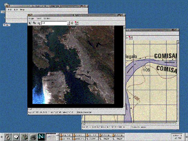
Figure 1
A screen shot of a viewer application created with the OSSIM library is shown in Figure 1. This tool can display a wide range of imagery and can also map data sets, roam, zoom, pan and track the latitude and longitude coordinates of the cursor.
The development staff at ImageLinks has been leading the development efforts with support from open-source developers around the world. The National Imagery and Mapping Agency (NIMA) had previously open sourced NIMA GEOTRANS and NIMA MUSE packages. These packages provide a valuable tool chest of certified map projection transformations, file formats and useful functionality that has been subsequently modernized to object-oriented code by the team.
The library is implemented in C++ and provides bindings to several libraries, including wxWindows, GDAL and GRASS. wxWindows is a framework that provides a generic GUI interface for programmers. The resulting code can then be targeted to Windows, UNIX and Mac platforms. GDAL is the geospatial data access library written by Frank Warmerdam that provides read/write access to a large number of geospatial data formats. GRASS is a well-known geographical information system with support for raster, vector and database functions. Python and XML support are also provided in the library.
OSSIM has been designed to support dynamic linking of image chains. Images can be opened in their native format and sampled on demand to fill a viewport on the screen or to generate an output product. The dynamic linking allows for reprojections, filters, combiners and other image processing functions to be added or removed easily to produce the desired result. Multiple image chains can be linked together to provide more complex products and views such as mosaics and fusions. OSSIM is designed to provide nondestructive processing, parameter driven options and a state-management system that allow for taking snapshots of a work in progress and restoring them during later sessions.

Figure 2
A conceptual overview of the OSSIM image processing chain is pictured in Figure 2. Functions from the library can be linked together dynamically and combined with other image chains to create the desired product or view. The end of those chains can be combined to create composite products as shown in Figure 3.


Figure 3
OSSIM can also attach imagery and maps in their native map projections (see Figure 4), window into a geographic area of interest and resample to common scales and orientations. Finally, Figure 5 shows that grids and annotations can be applied by linking that function within the chain.


Figure 5
Florida Tech University has been contributing to the efforts and specializing in feature extraction software. This allows roads and buildings to be identified from input imagery, as shown in Figure 6. A wide variety of functional modules can be accessed through the OSSIM library.
In conclusion, the OSSIM effort is building a state of the art set of libraries and tools for remote sensing and geographic information applications. Example applications are included in the distribution that demonstrate viewing, roaming, zooming and conversion between various map projections for geospatial imagery sets.
wxWindows: www.wxwindows.orgGDAL: www.remotesensing.org/gdalGRASS: www.baylor.edu/grassOSSIM: www.ossim.orgRemote Sensing: www.remotesensing.org
Mark Lucas is the Chief Technical Officer of ImageLinks Inc. of Melbourne, Florida. He is the founder of remotesensing.org, which promotes open-source development of remote sensing and geographical information systems software. He has a BS in Electrical Engineering and an MS in Computer Science and is a retired officer of the United States Air Force.
email: mlucas@imagelinks.com
